


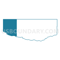
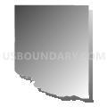
Norden Precinct, Keya Paha County, Nebraska
About
Outline

Summary
| Unique Area Identifier | 613327 |
| Name | Norden Precinct |
| County | Keya Paha County |
| State | Nebraska |
| Area (square miles) | 161.93 |
| Land Area (square miles) | 161.55 |
| Water Area (square miles) | 0.38 |
| % of Land Area | 99.76 |
| % of Water Area | 0.24 |
| Latitude of the Internal Point | 42.89597280 |
| Longtitude of the Internal Point | -100.06476390 |
Maps


Graphs
Select a template below for downloading or customizing gragh for Norden Precinct, Keya Paha County, Nebraska


Neighbors
Neighoring Voting District (by Name) Neighboring Voting District on the Map
- Ainsworth Precinct, Brown County, NE
- East Valentine Precinct, Cherry County, NE
- Garfield Precinct, Keya Paha County, NE
- VTD-Clearfield precinct, Tripp County, SD
- VTD-Lake precinct, Tripp County, SD
- VTD-precinct Jeanette, Todd County, SD
Top 10 Neighboring County Subdivision (by Population) Neighboring County Subdivision on the Map
- East Todd UT, Todd County, SD (2,858)
- Valentine precinct, Cherry County, NE (799)
- Johnstown precinct, Brown County, NE (287)
- Garfield precinct, Keya Paha County, NE (179)
- Norden precinct, Keya Paha County, NE (106)
- Millboro township, Tripp County, SD (35)
- Huggins township, Tripp County, SD (22)
- Beaver Creek township, Tripp County, SD (16)
Top 10 Neighboring Unified School District (by Population) Neighboring Unified School District on the Map
- Todd County School District 66-1, SD (9,612)
- Winner School District 59-2, SD (4,660)
- Valentine Community Schools, NE (4,515)
- Ainsworth Community Schools, NE (3,139)
- Keya Paha County Schools, NE (826)
Top 10 Neighboring State Legislative District Lower Chamber (by Population) Neighboring State Legislative District Lower Chamber on the Map
Top 10 Neighboring State Legislative District Upper Chamber (by Population) Neighboring State Legislative District Upper Chamber on the Map
Top 10 Neighboring 111th Congressional District (by Population) Neighboring 111th Congressional District on the Map
Top 10 Neighboring Census Tract (by Population) Neighboring Census Tract on the Map
- Census Tract 9402, Todd County, SD (5,161)
- Census Tract 9558, Cherry County, NE (4,287)
- Census Tract 9750, Brown County, NE (3,145)
- Census Tract 9716, Tripp County, SD (2,261)
- Census Tract 9559, Cherry County, NE (1,426)
- Census Tract 9754, Keya Paha County, NE (824)
Top 10 Neighboring 5-Digit ZIP Code Tabulation Area (by Population) Neighboring 5-Digit ZIP Code Tabulation Area on the Map
- 57580, SD (4,449)
- 69201, NE (4,005)
- 69210, NE (2,484)
- 68778, NE (572)
- 69221, NE (222)
- 69214, NE (203)
- 69220, NE (59)